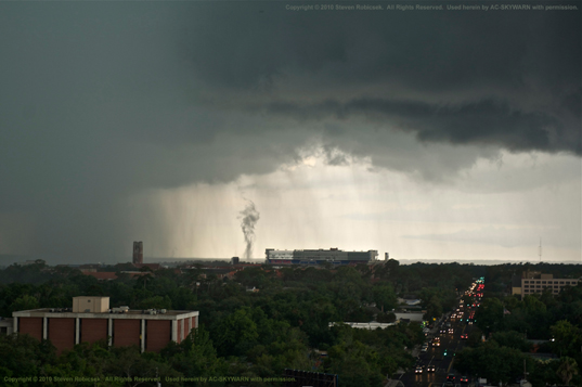
Gust Front Funnel Cloud (Gustnado) - June 29, 2010
Date/Time: June 29, 2010, 5:44pm ET
Location: Gainesville, FL
Submitted By: Dr. Steven A. Robicsek, MD, PhD
 Photo by Dr. Steven A Robicsek, MD, PhD. Taken June 29, 2010 at 5:44pm, from
atop the Seagle Building on University Avenue, looking west at the Ben Hill
Griffith Stadium.
A gustnado is not actually a "tornado", but something more like a large dust
devil. If you remember your spotter training, a true funnel cloud "hangs
pendant from a wall cloud." Gustnadoes are actually not part of or connected to
the cloud base.
From the
New World Encyclopedia...
"A gustnado (gust front tornado) is a small, vertical swirl associated
with a gust front or downburst. Because they are technically not associated
with the cloud base, there is some debate as to whether or not gustnadoes are
actually tornadoes. They are formed when fast moving cold, dry outflow air from
a thunderstorm is blown through a mass of stationary, warm, moist air near the
outflow boundary, resulting in a "rolling" effect (often exemplified through a
roll cloud). If low level wind shear is strong enough, the rotation can be
turned horizontally (or diagonally) and make contact with the ground. The
result is a gustnado. They usually cause small areas of heavier rotational wind
damage among areas of straight-line wind damage. It is also worth noting that
since they are absent of any Coriolis influence from a mesocyclone, they seem
to be alternately cyclonic and anticyclonic without preference."
This is truly an amazing shot. It's difficult enough to catch any KIND of a
funnel here in Alachua County; but to catch one placed perfectly right next to
the stadium like this is sure to destine this particular photo for some small
amount of fame in the least. Congratulations to Steve on nailing this one! This
is a great shot!
I've talked to Bill Quinlan, TV-20 Meteorologist, and he advises that in
talking with the NWS they thought they were seeing a convergence of two outflow
boundaries in the vicinity. Bill said that he was looking at the radar when
this was actually happening and he said that this funnel occured at the very
outside edge of the storm, where the outflow/gust front was.
We're not exactly sure just WHERE the funnel is actually touching down...behind
the O'Connell Center?...over Lake Alice? It is obviously picking up a lot of
dust. We know that the point of photography is at the Seagle Building. And the
funnel is located between the southern edge of the west wall of the
stadium and the south end zone score board (the building with the antennas on
top of it). This narrows things down a bit. But now we need someone at ground
level from that area who actually saw it so that they can point to us a
different specific direction and this will allow us to accurately pinpoint
exactly where the event actually occured. So if there's anyone who lives in
any of the dorms in that vicinity who actually saw this, please do contact us
so that we can try to narrow this down more.
This photograph demonstrates perfectly how there are things out there which can
LOOK like a funnel cloud or a tornado, but which actually are not. This is an
excellent "look-a-like", and I've been hunting for these kinds of
photographs for a while.
(This may well be the first-ever photograph of a gust front funnel ever taken
in Alachua County. ...And I think we're going to at least so say so herein -
until such time as someone comes along and proves otherwise to us,
anyway...which we actually encourage. :O) )
Note that while there was notification and some discussion between the TV-20 meteorologist and NWS-JAX, this is not technically considered a "severe weather" type of event. Thus, this was not noted in the Local Storm Reports database. So our record here is probably the only record that it occurred.
Text Products Issued:
Satellite Imagery:
RADAR Imagery:
(For a quick general description of the various radar products and each of their uses, see NCDC Radar Products.)
![[Alachua Co. SKYWARN Logo]](../images/logos/acskyw3d.jpg)


![Some spotting/chasing-related educational links]](../images/buttons/study1.gif)


![[ANIM: NOAA/NWS-JAX Wx Radio Page]](../images/logos/nwr.gif)
![[ICON: Alachua County FreeNet]](../images/logos/freenet.jpg)
![[ANIM: SKYWARN Pog]](../anim/skywbutn.gif)
![[ANIM: Vid-Cam]](../anim/mscamera.gif)